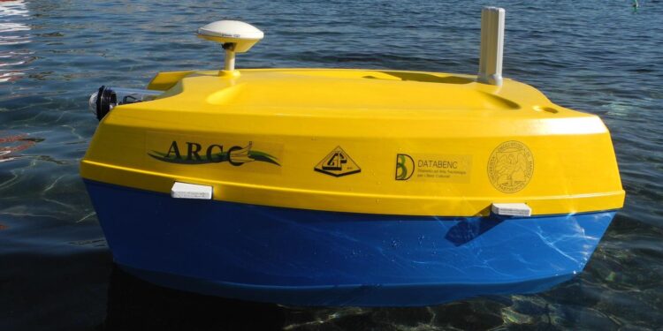
Its name is OR2 and it is an underwater drone designed by Parthenope University and the Urban Archaeological Park of Naples to explore the seabed
Drones are remotely controlled vehicles that fly over our heads, swim along our coasts and run along the pavements of cities all over the world. Created in the first half of the last century for purely military purposes, drones are now used for a wide variety of purposes. Amazon is experimenting with them for home delivery in the USA, while in Holland they have even designed an ‘ambulance drone’ capable of reaching heart attack victims in less than two minutes. In Italy, in Naples to be precise, an equally interesting use of drones has been imagined. A team from Parthenope University in collaboration with PAUN – the Naples Urban Archaeological Park – has designed and built a special underwater drone to explore the Bay of Naples. The craft was presented by Gerardo Pappone, Professor of Stratigraphic Geology and Sedimentology at the University of Naples Parthenope. “It is a redesigned, re-engineered prototype with a hull based on an existing model, capable of analysing the seabed with an echosounder and reconstructing georeferenced three-dimensional images using three cameras. In this way, submerged relics and vestiges of ancient Roman villas from the 1st and 2nd centuries BC are brought to light. Through synergies with other universities and private companies, we have collected all the data collected through different skills and methods of analysis, to build an updated cartography of the archaeological heritage of the Piazza Municipio area, facing the Gulf of Naples”.
Read also → Zip-Fastener Ship: the ZIP-shaped boat
The OR2 underwater drone
The underwater drone is called OR2 and will explore the seabed of the coastal area to depths generally no greater than 10-15 metres. Thanks to its sensors, the vessel will offer a highly accurate 2D and 3D representation of everything it encounters underwater. This will allow researchers to discover, observe and study precisely the underwater wonders of the Gulf of Naples. According to Prof. Pappone, “the aim of OR2 is the integrated representation of the Park area and the marine-coastal areas adjacent to Piazza Municipio. This activity will be accompanied by detailed mapping of archaeological, historical-monumental and geo-environmental assets, remote sensing and geological, hydrogeological, hydrogeothermal and geophysical prospecting. The surveyed data will form the basis for the elaboration of a plan for the knowledge and representation of the Heritage and for the definition of a decision support system for the elaboration (assessment) of the archaeological/historical/monumental and environmental risk/damage”.
You might also be interested in → Silver 2: the robot crab that will clean up plastic in the sea


